Thursday, February 27, 2014

Historical day!

Current Conditions:

Temperature: -11º F
Wind Chill: -29º F
Wind: 9 MPH NW
Dew Point: -23º F
Precipitation: None
Pressure: 1023.1 mb

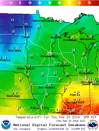
It is frigidly cold outside today. The temperature, as can be seen above, is well below zero, and the wind chill has dipped to nearly 30 below! Image 3 below shows the temperature across the Midwest and the color gradient gives a great picture of just how bitterly cold that it is. The winds have died down since yesterday, but the gusts are really driving the temperature even farther down. I also decided to add the pressure into the current conditions to describe whether we are in a low or high pressure dome. This feature will help to explain many weather phenomena throughout the rest of the semester. Newscasters are saying that today has the potential to be the coldest it has been on February 27th in 100 years, but we will see how the rest of it pans out. Another important event that is occurring today is the launching of the Global Precipitation Measurement satellite which will help identify water in the atmosphere. This was a global initiative put together by NASA and a Japanese aeronautical firm. Today is full of historical moments and desperately cold conditions.
Image 1: The image above provided by AccuWeather shows the arctic air mass that is being plunged across the Great Lakes region. Wisconsin is currently sitting on the cusp of this freezing air mass.
The jet stream is locking polar air over the Midwest and driving the continental polar air mass over the top of us. This explains why we are experiencing such frigid temperatures. Image 1 above shows the jet stream and the pushing of the cold air mass over the Midwest. In image 2 below you can see the current conditions of the polar jet stream via a 250 mb wind map. The blue regions describe areas of strong upper atmospheric wind strengths.
Image 2: The above image was created by UNISYS to show the polar jet streams direction and strength. The blue regions show where the winds are the strongest. There is a definite trend across the Midwest where the jet is riding and dipping over the Great Lakes region.
Image 3: The above image shows the temperature gradient in the Midwest. Looking at the scale bar at the top of the image it is apparent that northern Minnesota and parts of Wisconsin are experiencing bone chilling conditions.
Image 4: The image above shows the Minneapolis weather balloon sounding of the atmosphere. The yellow line on the left side of the diagram shows the air parcel. The white line on the right shows the temperature which if you look closely is showing quite the phenomena which is described further below.
FUN FACT: The image above shows some interesting data and phenomena present the atmosphere above us. We are experiencing an irregular formation of heat in the atmosphere where the air is warming as it is rising rather than cooling. The ground temperature is much cooler than the air just above us which could be creating a smog/haze over major cities due to pollution from vehicles.
Image 5: This UNISYS image shows current surface winds direction and speed. Minnesota and Wisconsin are receiving winds from the NW which is blowing even more of the arctic air into our region and thus cooling us further.
Predictions: I predict that tomorrow will be much like today. This arctic weather will most likely stick around for at least a few more days. The jet stream has locked the Midwest into a freezing frenzy with almost no end in sight. The temperatures will probably be low again tomorrow since the high pressure dome is still floating above us. The winds have been killing us the past few days and they will probably continue to do so over the next day or so.

Wednesday, February 26, 2014

Cold Again!

Current Conditions:

Temperature: 12º F
Wind Chill: -5º F
Wind: 16 MPH SW
Dew Point: 2º F
Precipitation: None

Greetings and welcome back to the tundra! The temperatures have dropped ferociously over the past few days and the wind chill today is no different. The snow has been blowing all day long with the strong winds and the skies have become overcast. The snow on the roads and sidewalks has been melting slightly during the day, but becoming ice at night. It is treacherous just to walk outside of your front door. The hope for spring coming soon has been diminished by the polar jet stream, but there is still a chance that it could begin to warm up by the end of March.
Image 1: Above is a UNISYS wind map of the Midwest. Wisconsin is experiencing strong winds out of the south west. The trend of winds in the image appears to be moving in a counterclockwise rotation which indicates that a low pressure system is present.
If the low pressure system from image 1 above stays in its current space now and further develops then there is a slight chance that it may snow in the next few days. The winds have been so high that our wind chill temperatures have been dipping quite low. The winds may be coming out of the SW but they are chilling in our cold air mass. The Image below shows the jet stream at its current state which also shows why the temperatures have been so cold lately.
Image 2: The above UNISYS image shows the current polar jet streams path of travel. The jet stream is still dipping down across the Midwest which is keeping chilly air over our region.
Image 3: The NOAA image above shows the temperature gradient across the Midwest. Parts of Wisconsin and Northern Minnesota are experiencing polar temperatures.
I predict that the weather tomorrow will be cold once again and if the low pressure system to our north dissipates then the skies should be once again clear. The temperature should be very low with wind chills in the negative 20's. Image 4 below shows the incoming high pressure which should clear the skies again and drop the temperatures even more. It should once again be very windy tomorrow with winds traveling in the teens (miles per hour). There is snow to the north of us currently, but there shouldn't be any in Eau Claire tonight or tomorrow.
Image 4: The above image shows radar data and pressure systems across the continental United States. There is currently a low front over the Midwest with a high front moving in behind it.

Tuesday, February 25, 2014

The house is on fire!

Current Conditions:

Temperature: -2° F
Wind Chill: -18° F
Wind: 9 MPH W
Dew Point: -12° F
Precipitation: None

Today was bitterly cold and this trend should continue throughout the week. One estimate that I saw for the wind chill tomorrow had it dropped to -40º F! The winds have picked up quite a bit over the past few days as well reaching gusts above 20 MPH. While the skies are clear and the sun is shining the cold winter weather keeps up due to the dipping of the polar jet stream. As the week goes on I see it staying cold and somewhat windy. The image below shows a very good description of why we are stuck in the cold air that we are currently in. I think that tomorrow will once again be extremely cold and mildly windy. Look for clear skies and bitter wind chills across the Midwest.
Image 1: The above image provided by accuweather shows the polar and pacific jet streams and the air that is hovering around them.

Monday, February 24, 2014

Monday.

Current Conditions:

Temperature: 9º F
Wind Chill: -8º F
Wind: 22 MPH W
Dew Point: -2º F
Precipitation: 0 inches in the last 24 hours

Today is a cold one. The skies are clear and the sun is shining, but the temperature is still very low. The winds are gusting in the teens to 20's. The snow from the weekend is frozen onto the sidewalks which has also created hard snow piles. Salt deposits have been placed on sidewalks and roads which are helping, but its a slow process. There is a slight chance that Eau Claire could receive snow tonight. Image 1 below shows the radar data at its current state. There is snow across the great lakes and over South Dakota, so it could possibly make its way to our area.
Image 1: The above image shows the snow fall that is currently happening across the Midwest. There are large pockets of snow over South Dakota and the Great Lakes. Wisconsin is currently not receiving much precipitation in any form.
The temperatures are very low all across the Midwest. This is very apparent in image 2 below. The temperature is very chilly across Wisconsin, Minnesota, and the Dakotas and becomes warmer as you move farther south.
Image 2: The image above is provided by noaa.gov and shows the temperature gradient across the Midwest. As can be seen in the image above the temperature moves in lateral lines of cold air at the top and warmer near the bottom.
The wind in image 3 below shows the clockwise rotation that is associated with a high pressure system. Winds are also much stronger over the Dakotas and the Great Lakes. The high pressure system makes sense with why there is a lack of clouds in the sky and the cold conditions as well.
Image 3: The image above shows the wind speed and direction across the Midwest. The winds are moving in a clockwise rotation which is a sign that a high pressure system has developed.
Image 4: The image above, which is provided by the GOES satellite, shows the water vapor content in the air. There is currently little to no water vapor content in the air over the Midwest.
Water vapor, much like the index in image 4, often can fuel storms and judging by the image above it would appear that there is small amounts of water vapor currently over the eastern United States which correlates to almost no storms.
Image 5: The above image shows pressure systems, fronts, isobar lines and radar data. There is currently a stationary front along the Rocky mounts and a cold front across the most southern states.
I predict that tomorrow will will be much like today by looking at the pressure systems that are currently in our region. The temperatures will most likely stay low and may even dip farther below zero. There is a slight chance of snow tomorrow on the forecast which makes sense because of the amount that is currently over the Dakotas. The high pressure system's winds could potentially push some of the snow into our area. The skies should be partly cloudy but you should expect to the see the sun for most of the day. Dress warm!

Thursday, February 20, 2014

The Storm.

Current Conditions:

Temperatures: 36º F
Wind Chill: 29º F
Wind: 10 MPH E
Dew Point: 32º F
Precipitation: It's coming down hard as we speak!

The storm has begun! The snow is falling like crazy currently. I tried to get a good picture, but it didn't turn out the best. Expect a picture of the snow fall as the night goes on. There are several mighty factors that are fueling this massive snow storm. They include a powerful low pressure system, vast amounts of water vapor, and the polar jet stream. There are several other factors fueling this process that I will talk about as we progress further into today's post. The temperature is still very high for the time being as the low pressure system pulls air from the south and west into our region. We are projected to get around 12 inches of snow over the next day which is truly incredible. The University has already closed night classes and depending on how long the snow lasts it could potentially close tomorrow as well. Below is an image of the current temperatures in the Midwest.
Image 1: The image above shows the temperature in the Midwest. 
The two images below show what is currently happening in the Wisconsin skies. Image 2 shows the water vapor index and its current conditions in the eastern United States. There is a massive amount of vapor sitting over Wisconsin and Minnesota currently. It's somewhat difficult to see in the image but the vapor is moving with the low pressure system and rotating counterclockwise over the two states. Image 3 below is an image showing the currently wind direction and strength over the Midwest. The image shows the distinct pattern that is associated with a low pressure system. Between the low pressure, winds and vapor the snow storm is going crazy right now.
Image 2: The image above is provided by the GOES satellite and shows the amount of water vapor in the clouds.
Image 3: The above image shows wind direction and speed in the Midwest. There are very high winds across the Dakotas and Nebraska.
The image below shows the radar conditions of the Midwest weather at its current state. The image shows where the areas of difference in precipitation has occurred. Eau Claire is currently somewhere in the snow to ice range, however in the last few minutes the snow has become much larger. We have near white out conditions.
Image 4: The image above is provided by noaa.com and shows the different types of precipitation in the Midwest. 
Image 5: This image was provided by The Weather Channel and shows radar data, pressure systems, front and isobar lines. There is a massive low pressure system over the Midwest which is wreaking a snowy havoc. 
While today is snowy and wet I think that tomorrow we will start to experience cold weathers. As the low pressure moves out of our region and as the jet stream dips back down over the Midwest the temperatures should drop which will create an icy landscape. The weather over the weekend should be near to miserable as the temperatures dip back into the negatives and the winds increase in speed as high pressure systems develop in our region. Good luck driving tonight and look for an update tomorrow!

Tuesday, February 18, 2014

B-E-A-UTIFUL Day!

Current Conditions:

Temperature: 33° F
Wind Chill: 25° F
Wind: 9 MPH S
Dew Point: 23° F
Precipitation: 0.7 inches of snow in the last 24 hours

A high in the 30's with warming conditions on the forecast? What more could someone ask for? The winds are shifting and are now out of the south, but you can expect them to shift even more. The wind will most likely be blowing right out of the west by tomorrow. The jet stream has finally shifted northward and the deep trough has moved back up in the polar regions. While this means that we will receive some warmer weather it also means that the great lakes region will still receive snow. After the week concludes there is a strong possibility of cold temperatures again over the weekend. Image 1 below shows the temperature across the Midwest currently. The whole region is warm currently.
Image 1: The image above shows the temperature gradient in the Midwest. There is a warming trend across the region.
There has been some interesting phenomena happening on the east coast over the past few weeks where they have been buffeted by storms. This can be illustrated through image 2 below where the dark blue regions of water vapor. Water vapor feeds into these storms and further fuels the rain/sleet/snow.
Image 2: This image contains water vapor images from across the Midwest and east coast. The large amount of vapor located near Maine and in Canada is the remnant of the storm that most recently hit the coast.
Image 3: This image provided by noaa.com shows the wind direction and strength across the Midwest. The winds are shifting from coming out of the South to coming out of the West.
Image 3 above shows how the surface winds are changing as the day goes on. The winds coming out of the west are much stronger and are about to invade Wisconsin as the night goes on. These westerly winds will cause a warm up to further occur in the Midwest over the next few days.
Image 4: This image was created by The Weather Channel and contains pressure systems, fronts, radar data, and wind isobar lines.
I predict warm conditions again tomorrow as the westerly winds reach the Midwest. There is a good chance that we will see more snow by tomorrow night or early Thursday morning. This is prevalent in image 2 above which shows a vast amount of water vapor above the Midwest. Temperatures should be in the 30's again with stronger winds coming out of the west. It will most likely be cloudier tomorrow, especially as the night goes on. You should be able to track the cloud cover as we begin to get snow tomorrow.

Monday, February 17, 2014

President's Day

Current Conditions:

Temperature: 19º F
Wind Chill: Feels like 19º F
Wind: 3 MPH S
Dew Point: 17º F
Precipitation: 3.1 inches of snow in the last 24 hours

Today was gorgeous! The temperatures were high in the mid 20's and there was almost no wind to speak of. It snowed almost all day long, but it only accumulated to about 3 inches. The sidewalks were treacherous as the snow was compacted by many scurrying feet. The weather over the weekend was great and its only projected to get better from here on out. The only stipulation to the increase in temperature is an increase in snow with it. If you have boots, wear them. If you don't have boots, buy some. As you can see in image 1 below, it is 10 pm and the temperature is still in the high teens so you know that we are in a warm up.
Image 1: NOAA's image above shows a temperature gradient across the Midwest.
The forecast for the rest of the week is very agreeable since the temperature doesn't really dip below 20º F. There is a hefty amount of snow coming our way along with these rising temperatures. In image 2 below you can see an interesting occurrence of fog coming across lake Superior and into Wisconsin which is most likely a cause of the dew point being so high.
Image 2: The image above shows weather and types of precipitation in the Midwest. We are currently experiencing an interesting fog phenomenon. 
My predictions for the weekend were fairly accurate. I predicted the vast amount of snow that the Midwest would be receiving along with the temperature increase. Image 3 below shows how the winds have shifted in the Midwest since Friday. We now have a weak southerly wind.
Image 3: The above image shows the current wind conditions in the Midwest. Wisconsin is experiencing almost no wind across the entire state.
Image 4: This image shows pressure systems, fronts, radar weather and wind isobar lines. The Great Lakes region is currently being buffeted by snow. It looks like the east coast could yet again be receiving another snow storm.
I predict, much like the forecast, that tomorrow will be warm with flurries of snow. There is a low pressure trough sitting above our area which keeps the temperatures warm, the winds coming out of the south and snow. I don't see much of a change occurring in the weather conditions over the next day or so. I would highly suggest being prepared to shovel or dress for the snow. The jet stream's trough has moving north which has helped to warm the continental U.S. up as well. We should see a heat trend on the rise, but also more snowy conditions. Stay tuned as we enter an exciting and warmer next few days.

Friday, February 14, 2014

Valentine's Day

Current Conditions:

Temperature: 11º F
Wind Chill: -1º F
Wind: 8 MPH NW
Dew Point: -2º F
Precipitation: 0 inches in the last 24 hours

The weather today was exceptional in the eyes of a man from the north. The temperature was perfect today. It was in the high teens during the afternoon and for once you really didn't need a jacket. The winds were slightly higher today than they have been the past few days but it really didn't affect the great weather. The cloud cover was also pretty sparse throughout the day. The current temperature and weather conditions are pretty stable considering its cold, but no precipitation currently.
Image 1: The image above shows the temperature gradient across the Midwest along with current temperatures in big cities.
My projections for today's weather were fairly accurate, however there wasn't as much snow as I had thought. I expected a lot more snow due to the converging air masses, but they didn't really create a lot of snow. Image 2 below shows winds blowing from the NW across Iowa and Wisconsin, but out of the South in the Dakotas.
Image 2: Noaa.com's image above shows the surface winds across the Midwest. The winds exhibited above are relatively weak when looking at the "flag" portion of the bars.
Image 3: The Weather Channel's image above shows pressure systems, fronts, wind isobars, and radar data.
In image 3 above it is apparent that the storm that obliterated the east coast over the past week as dissipated, however it would appear that there is a new one forming over Virginia. There is also some snow and rain forming over the Rockies. I predict that we will once again receive snow tomorrow, but the real question is about how much. I think that temperatures will be in the low teens to high tens. The skies should be overcast to accommodate the snow as well. Enjoy the cold conditions! Happy Valentine's Day!

Thursday, February 13, 2014

The Eastern Storms!

Current Conditions:

Temperature: 20º F
Wind Chill: 10º F
Wind: 9 MPH W
Dew Point: 16º F
Precipitation: 0.2 inches of snow in the last 24 hours

Today was yet another great day! The University got the sidewalks cleaned before 8 AM and it was relatively warm today. The weather was nice and the snow stayed to a minimum throughout the afternoon. The sky was very overcast all day and the wind whipped around at points as well. While Wisconsin had decent weather today the east coast can't say the same. Earlier in the week Georgia and other southern states got nailed by a huge snow/ice/rain storm caused by converging cold and warm air off of the coast. Today the storm moved north along the east coast and has been buffeted them all day. This can be seen in image 1 below.
Image 1: The image above shows pressure systems, fronts, radar data, and wind isobars. A storm can be seen buffeting the eastern coast. The U.S. is currently smothered in low pressure systems.
The temperature has increased so much in the Midwest over the past two days and this is apparent in image 2 below. It is currently much colder in Minnesota and the Dakotas than Wisconsin. This is most likely occurring because of the southerly and westerly winds from the low pressure system.
Image 2: This image proved by noaa.com shows the current temperatures across the Midwest.
The Midwest is encountering some crazy precipitation in the weather currently. This is apparent in image 3 below. Eau Claire, WI is getting a nice dusting of snow according to the radar and from the looks of it we may be getting more continual throughout the night.
Image 3: This image is presented by noaa.com and shows the type of precipitation that a region is currently receiving. Our area is currently covered in snow and receiving more.
My predictions from yesterday were decent, but I was incorrect in assuming that the temperature wouldn't increase to 30º. Today in class we learned more about diabatic and adiabatic pressure, so hopefully I will be able to show some examples of them as the season goes on.
Image 4: This image shows the current surface winds and what mischief that they are up to.
I think that the weather tomorrow could be very nice in respects to cloud cover, but with changing winds there is a chance of colder air moving back into the area. I would expect there to be partly cloudy skies with temperatures in the teens. As can be seen in image 4 above, the surface winds are still moving in a counterclockwise motion which means that the low pressure system is still sitting on top of the Midwest. Don't expect much to any snow tomorrow or over the weekend! Until next week, stay classy!

Wednesday, February 12, 2014

Snow?

Current Conditions:

Temperature: 20º F
Wind Chill: 20º F
Wind: SW 3 MPH
Dew Point: 12º F
Precipitation: 0.4 inches of snow in the last 24 hours

Today's weather was beautiful! It was a warm upper teen to 20º heat wave. As the day went on it only got hotter. The wind was hardly present all day long and thus kept the wind chill to the same temperature as the regular air. It snowed today as well but not nearly as much as I had predicted originally. The light snow that we did receive was slushy due to the warmer conditions which make sidewalks slick throughout the day.
Image 1: This image shows the temperature range in the Midwest. It is currently in the upper teens in Eau Claire, WI.
The forecast for today called for snow almost all day long, which didn't occur. Instead, we received overcast skies and high temperatures all day. It will get cooler tonight but there is a decent chance that snow may come back again tonight for a dusting.
Image 2: This image shows pressure systems/fronts, radar, and isobar lines. There is a high cold front just north of Wisconsin currently, but the low pressure should persist.
My predictions from the previous day were fairly accurate, however Wisconsin didn't receive nearly as much snow as I had thought. It was overcast and warm throughout the daylight hours though. It was quite the experience to watch the low pressure move into our area and with it cloudy conditions.
Image 3: The image above shows the surface winds in the Midwest. There is still a low pressure system above us. This is apparent because of the counterclockwise motion of the winds.
I predict that tomorrow will be much like today. It will most likely snow even more as yet another low pressure system slides into our area. The temperatures should stay in the 20s even though the official forecast says that it will be 30º. I think that there won't be much wind either because of the low pressure. Image 3 above shows the counterclockwise motion of the surface winds which indicates low pressure. Break those boots out again for more snow tomorrow!

Tuesday, February 11, 2014

The Cincinnati Fire Kite

Current Conditions:

Temperature: 9º F
Wind Chill: Feels like -6º F
Wind: 14 MPH S
Dew Point: -4º F
Precipitation: 0 inches in the last 24 hours

Some of you may be wondering why today's title is "Cincinnati Fire Kite," well today in lab we learned how to make a fire kite. It was a great demonstration of how hot air is less dense than cold air and hence rises. With so much cold air in our region the kites flew high! Back to the weather...It was once again chilly in Eau Claire, WI. The forecast for the week projects temperatures into the 30s, which means shorts weather to our ears. We are also guaranteed to get snow tonight still as the low pressure system that has been making its way south comes across the state. The skies have been cold and windy all day long, so it will be quite the change to be overcast and see snow fall yet again. The temperature is staying above 0º which is a pleasant change and is projected to get even higher tomorrow.

Image 1: The image displays a temperature map of the Midwest. It appears that a warm up is coming to Wisconsin shortly. 
 In Images 2 and 3 below it is apparent that Wisconsin is about to see a major difference in weather. Image 2 shows the type of precipitation that is occurring, while image 3 simply shows cloud cover. Wisconsin is about to get masked in a shroud of clouds while getting even more snow dumped upon the already heaping amount.
Image 2: Radar image of the Midwest describing precipitation and wind patterns. There is a large amount of snow coming our way.
Image 3: Image showing the cloud cover by percentage in the Midwest. Wisconsin is still fairly clear but will become overcast as the night wages on.
The predictions that I had made from yesterday were fairly accurate, however it was actually warmer today than it was yesterday. It was great having class today because we were able to learn even more new material that is relevant for our skills to interpret the weather.
Image 4: This image shows the wind direction and speed. The winds are currently low and coming out of the south.
Image 5: This image from The Weather Channel shows radar, isobars (wind) and pressure systems/fronts. 
I predict that tomorrow will be very overcast and snowing like a madman. NOAA.com's forecast is that it will snow all day tomorrow into Thursday where we will see an increase in temperature. It would be fantastic to finally see some warmer temperatures. Image 5 above shows the low pressure unit that will be hitting Wisconsin later tonight while image 4 above shows winds coming out of the south. As the low pressure system gets closer there should be a noticeable wind change where it will rotate counter clockwise away from the the low pressure. Tomorrow will be snowy so make sure to wear boots and snow pants!

Monday, February 10, 2014

A New Week!

Current Conditions:

Temperature: -5º F
Wind Chill: -5º F
Wind: Calm (noaa.com)
Dew Point: -13º F
Precipitation: 0 inches in the last 24 hours

Today was bitterly cold according to The Weather Channel. The skies were relatively clear all day long and sun was very bright, yet the temperature has persisted to stay very low. We have been stuck in a cycle of high pressure systems over the past week or so and thus have had very chilly temperatures. The temperature is projected to drop even more tonight and get below -10º. Needless to say, it was a good day to stay inside with a warm drink in hand. Image 1 below shows just how cold the Midwest currently is.

Image 1: This image shows the variation of temperatures in the Midwest. The majority of the region is in the extreme left of the spectrum.
The forecast for the day was pretty spot on with open skies and frigidly cool air. It was somewhat windy earlier which fueled the wind chill to drop even lower. Image 2 below shows the pressure systems that are moving across the United States. There is currently a low pressure system to the north that is projected to move over Wisconsin by Wednesday and bring with it, warm air.

Image 2: This pressure map, overlayed with radar and isobars shows the movement within the United States currently. 
My predictions for the weekend were a bit off considering I projected the low pressure systems (found in the southern U.S. in Image 2 above) would move into our region and with them bring warm air with cloudy skies. High pressure systems most likely have more of an effect on the low pressure systems than I had originally thought.

Image 3: This image shows a map of the winds in the Midwest via the use of wind vanes. As can be seen, Wisconsin is experiencing almost no wind in the NW part of the state.
I think that tomorrow will be much like today based on the High pressure systems in the area along with a lack of surface air movement. The temperatures should also be similar if not colder as the high pressure moves above Wisconsin. It should be windier tomorrow though since there is a projected low pressure system moving into our area by Thursday. This could increase the wind chill temperatures and make it even colder until the warmer air is right above us.

Friday, February 7, 2014

Can you feel the Pressure?

Current Conditions:

Temperature: -3° F
Wind Chill: Feels like -20° F
Wind: 10 MPH SW
Dew Point: -11° F
Precipitation: 0 inches in the last 24 hours

Believe it or not it is actually colder today than it was last night when we were getting wind chill advisories! The expected high for today is right around 12° F with a big drop into the negative tonight. While it is always great to see the sun shining, it generally means cooler temperatures in our neck of the woods during this time of the year. Much like yesterday we have a faster wind that can pick up with gusts, so don't forget to wear a scarf when going outside!


The forecast for today includes clear skies, ice cold gusts and negative temperatures for a majority of the day. There are some low pressure systems coming inland off of the west coast which could affect us within the next few days. Partly cloudy tonight with a chance of snow tomorrow, which is dependant on the low pressure systems moving our direction. The winds from the south west and overall jet stream pattern would suggest that we will indeed be getting hit by the low pressure.


It looks like my predictions from last night were near to spot on with today's weather!

 
I predict that tomorrow might see some cloudier skies, higher temps and snow. It all depends on when the low pressure system hits our area and how hard, but I think that it might make its way over by tomorrow morning to afternoon. This weekend could also be charactersistic of the same fate overall. Let the high temperatures come our way, but hopefully now snow follows it! Have a great weekend and stay tuned for more weather updates!


Thursday, February 6, 2014

You're as cold as ice!

Current Conditions:

Temperature: 0º F
Wind Chill: -18º F
Wind: 13 MPH SW
Dew Point: -11º F
Precipitation: 0 inches in the last 24 hours

It is bitterly cold in Eau Claire, WI currently! The whole country is experiencing odd phenomena at the moment. California is seeing encountering its worst drought in the past century, the South East is experiencing snow and doesn't know what to do about it, and we are having crazy cold winds! While perusing through many different weather sources today I noticed some interesting trends. With the jet stream dipping across most of the central United States the temperatures have dropped dramatically. High pressure systems have been fighting against each other across the U.S. as well pushing air into the midwest.


I predict that tomorrow will be another clear day like today with some possible haze. It should continue to stay cold as well. I wouldn't be shocked if tomorrow stayed below zero. Depending on this wind situation and fronts that are on our periphery, we could continue to have another windy day ahead of us.