Temperature: 36° F
Wind Chill: 32° F
Wind: 5 mph N
Dew Point: 35° F
Precipitation: None currently
Pressure: 1005.4 mb
It may the morning of Wednesday, but yesterday's story needs to be told. It was relatively cold all day yesterday and it continued to rain for a majority of the day. The winds were gusting into the twenties and while the rain was light it was also constant. The temperature hung around the 30's and 40's but felt chillier at times due to the rain and wind chill. The ground currently is fully saturated so Hortonian overland flow is occurring which is causing drain pipes, streams and rivers to flood slightly. This trend will continue if the rain persists further into the week.
 |
| Image 1: The Accuweather image shown here displays the predictions for the weather later on in the week and going into the weekend. Violent storms are projected to keep ravaging the southern states with T-storms and tornadoes. Meanwhile, the west is getting hot dry air again and the northern states are getting bombarded with rain. |
 |
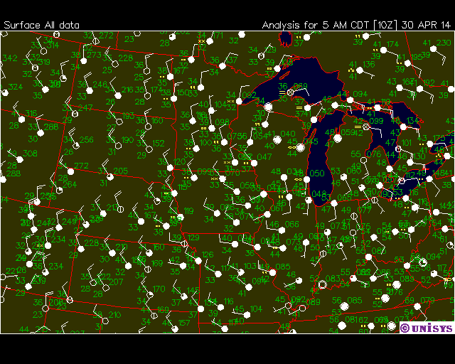
| Image 2: The image above shows pressure systems, fronts, isobar lines and radar data. The low pressure system that has been whipping across the U.S. is now sitting on top of Wisconsin and with it has brought rain. There is also a large occluded front extending from WI eastward. This system appears to be dying. |
 |
| Image 3: The sounding shown here was taken from Minneapolis, Minnesota. It seems that the dew point and temperature are just barely apart in most of the atmosphere but are possibly colliding around 950 mb. There is most likely no rain or light rain there. |
 |
| Image 4: The UNISYS image here shows wind speed, wind direction and cloud cover. Eau Claire is experiencing almost no wind and the wind that we do have is coming out of the north. The winds should continue to become more westerly a the week progresses. We are also seeing overcast skies. |
I predict that today will be a cold day yet again. There shouldn't be much rain today, however with northern winds it will be very cold. It will probably stay under 40° F all day and I don't see the overcast skies leaving any time soon either. The current low pressure system that is causing these storm to persist should die out in the next few days and winds should start shifting very soon. There is currently a high pressure system sitting over Montana. That system should reach us by the weekend, so I believe that skies will clear up by then. There is a chance that the weekend could be warmer than the past week with clearer skies.
No comments:
Post a Comment