Wednesday, May 7, 2014

Tuesday, May 6th, 2014

Current Conditions:

Temperature: 50° F
Wind Chill: 47° F
Wind: 7 mph E
Dew Point: 38° F
Precipitation: None, currently
Pressure: 1010.7 mb

Yesterday was a beautiful day and ended up being much like I had predicted it to be minus the storms beginning last night, which they didn't. It was in the 60's yesterday with gusting winds in the 20's. The morning began with relatively clear skies which became more overcast as the day/night went on. The winds were out of the west as of last night but as you can see in the current conditions that has changed slightly.
Image 1: The Accuweather image here shows the areas that will be affected by these severe T-storms that are going to move through later today and tonight. The storms are expected to have very high winds and possible hail. Almost all of Wisconsin will be under advisory for this storm.

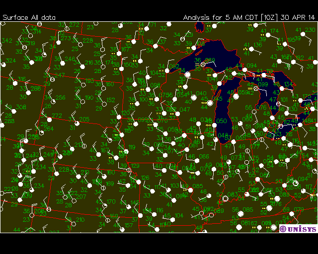
Image 2: The image above shows fronts, pressure systems, isobar lines and frontal systems. Wisconsin is experiencing overcast skies with some stormy weather across the central part of the state, but it is very spotty. As the low pressure systems further develop and move over WI the storms should really start to pick up.

Image 3: The weather sounding above was taken from Minneapolis, Minnesota. The sounding shows no significant risk for precipitation, however it seems like rain is looming in the horizon. This sounding could have been taken earlier this morning. Watch the LI and KI values throughout the day for instability in the atmosphere.

Image 4: The UNISYS image above shows wind direction, wind speed, and cloud cover. Eau Claire is currently experiencing overcast conditions with slight winds out of the east. These winds are subject to slight change as the T-storms develop and move through.
I predict that the rest of the day will be rainy or near to rain. The sky is giving he surface a yellowish tint right now and in my experience that isn't necessarily a good sign. There will definitely be large T-storms rumbling through as the day unfolds, but the question is when. It seems like the low pressure system to the south of us needs to move northward or something if we are going to get severe weather. I would count on rain today and nasty weather tonight.

Monday, May 5, 2014

Monday, May 5th, 2014

Current Conditions:

Temperature: 52º F
Wind Chill: 49º F
Wind: 10 mph SE
Dew Point: 34º F
Precipitation: None
Pressure: 1015.7 mb

It was an incredible day! The temperature was in the 60's this afternoon. It was slightly breezy all day, but mostly sunny with few clouds in the sky. The clouds that were in the sky were mainly cirrus. The weather from last was terrible, so it was refreshing to finally have some warm weather. Winds picked up as the night went on.
Image 1: The Accuweather image above shows the expected T-storm region that will occur on Wednesday. Most of the Midwest will be engulfed in the storms and it will actually be the first big T-storm for us this summer.
Image 2: The image above shows radar data, isobar lines, pressure systems, and fronts. The Midwest isn't experiencing much right now, but will see T-storms in the next few days. Image 1 says that the storms will hit Wednesday.
Image 3: The sounding above was taken from Minneapolis, Minnesota. There is a huge inversion in the atmosphere which is very odd. I'm not really sure what could be causing that at this time of the year, so I'm guessing that its an error.
Image 4: The UNISYS image above shows wind direction, wind speed and cloud cover. Eau Claire is experiencing clear skies with winds out of the south east around 10 mph. The winds will start to shift and go crazy as the string of low pressure systems from the west get closer.

I predict that tomorrow will be partially cloudy in the early afternoon and becoming increasingly cloudier with nimbus clouds into the night. Rain should start later in the night and thunderstorms should ensue during the day. A good sounding will should the instability in the air before the storms start so keep an eye on the blog for that. The temperature should be near 60º tomorrow and dipping down into the 40's as the rain begins. Expect windy conditions with massive gusts of air. Dress for a wind day tomorrow!

Friday, May 2, 2014

The Weather!

Current Conditions:

Temperature: 43º F
Wind Chill: 39º F
Wind: 7 mph SW
Dew Point: 38º F
Precipitation: None
Pressure: 1007.4 mb

The past few days have been a hectic roller coast ride. The temperatures have been increasing slightly each day and now it has reached into the 40's. The rain has also finally stopped, so hopefully with westerly winds we can experience a warm up which will really bring out the green in the grass. The skies were mostly overcast throughout the past few days with a few breaks in the sky. The sun finally cut through the clouds last night due to shearing of the clouds in the upper atmosphere.
Image 1: The accuweather image above shows a massive source of heat that is rising out of the equator and up into and over Texas. This sustained heat may lead to drought in the region that Accuweather analysts have been predicting for a while.
Image 2: The image above shows the pressure systems, fronts, isobar lines, and radar over the U.S. There is currently a low pressure system situated above Minnesota which is keeping the Midwest in overcast skies. There are also some high pressure systems over the Rockies that could make their way into our region over the new few days. They would bring warmer air and clearer skies.
Image 3: The image above shows the weather sounding from Minneapolis, Minnesota. The dew point and temperature are nearly touching at 850 mb, but mostly are apart. There shouldn't be any rain today. 
Image 4: The UNISYS image above shows wind direction, wind speed, and cloud cover. The winds are currently out of the west to south west. The skies are also overcast.
I predict that it will be a much better weekend than the rest of the week has been. Temperatures should be in the 40's to 50's throughout the weekend with cloud cover moving out as the high pressure systems move in. There should be any rain either due to the lacking of a low pressure system and occlusion that could stay in the area. Winds should also continue to be out of the west.

Wednesday, April 30, 2014

Tuesday, April 29th, 2014

Current Conditions:

Temperature: 36° F
Wind Chill: 32° F
Wind: 5 mph N
Dew Point: 35° F
Precipitation: None currently
Pressure: 1005.4 mb

It may the morning of Wednesday, but yesterday's story needs to be told. It was relatively cold all day yesterday and it continued to rain for a majority of the day. The winds were gusting into the twenties and while the rain was light it was also constant. The temperature hung around the 30's and 40's but felt chillier at times due to the rain and wind chill. The ground currently is fully saturated so Hortonian overland flow is occurring which is causing drain pipes, streams and rivers to flood slightly. This trend will continue if the rain persists further into the week.
Image 1: The Accuweather image shown here displays the predictions for the weather later on in the week and going into the weekend. Violent storms are projected to keep ravaging the southern states with T-storms and tornadoes. Meanwhile, the west is getting hot dry air again and the northern states are getting bombarded with rain.

Image 2: The image above shows pressure systems, fronts, isobar lines and radar data. The low pressure system that has been whipping across the U.S. is now sitting on top of Wisconsin and with it has brought rain. There is also a large occluded front extending from WI eastward. This system appears to be dying.


Image 3: The sounding shown here was taken from Minneapolis, Minnesota. It seems that the dew point and temperature are just barely apart in most of the atmosphere but are possibly colliding around 950 mb. There is most likely no rain or light rain there.

Image 4: The UNISYS image here shows wind speed, wind direction and cloud cover. Eau Claire is experiencing almost no wind and the wind that we do have is coming out of the north. The winds should continue to become more westerly a the week progresses. We are also seeing overcast skies.

I predict that today will be a cold day yet again. There shouldn't be much rain today, however with northern winds it will be very cold. It will probably stay under 40° F all day and I don't see the overcast skies leaving any time soon either. The current low pressure system that is causing these storm to persist should die out in the next few days and winds should start shifting very soon. There is currently a high pressure system sitting over Montana. That system should reach us by the weekend, so I believe that skies will clear up by then. There is a chance that the weekend could be warmer than the past week with clearer skies.

Friday, April 25, 2014

Friday, April 25, 2014

Current Conditions:

Temperature: 38° F
Wind Chill: 34° F
Wind: 5 mph S
Dew Point: 38° F
Precipitation: None, light fog
Pressure: 1006.8 mb

This morning's conditions are far better than yesterdays. It is slightly foggy this morning, but most of it has moved away. It seems like the sky is trying to brighten and shear the clouds. According to the current conditions above it would seem that there should be rain right now since the temperature and dew point are the same, but alas it is dry outside. It is a bit colder right now than it was earlier in the week, but it should warm up in the afternoon hours.
Image 1: This Accuweather image shows a massive section of eastern states along the coast that are/will be pelted by the thunderstorms that are rumbling through the states. According to the image there are strong winds, "white out" conditions due to the rain, and sleet/hail.

Image 2: The image above shows pressure systems, fronts, radar data, and isobar lines. There is currently a low pressure system over northern Wisconsin which explains the southerly winds since low pressure systems spins winds counterclockwise.

Image 3: The weather sounding above was taken in Minneapolis, Minnesota. It shows the dew point and temperature converging around 850 mb, then quite an inversion in the dew point after that.

Image 4: The UNISYS image above shows wind speed, wind direction, and cloud cover. Eau Claire is currently experiencing overcast skies with very low winds. The winds that we do have are coming out of the south due to the low pressure system sitting at the top of the state.
I predict that the new few days will shape up a bit with temperatures in the 50's. There is another cold front developing and making its way east again, so that may bring more rain with it. This cold front is looking much like its predecessor in that it also has low pressure systems riding along with it and there is an occluded front sitting at its helm. Sunday or Monday should be when we receive rain from the frontal unit. In the mean time expect decent weather that is a bit chillier than last weekend.

Wednesday, April 23, 2014

Wednesday, April 23rd, 2014

Current Conditions:

Temperature: 42º F
Wind Chill: 38º F
Wind: 7 mph E
Dew Point: 39º F
Precipitation: Sprinkling
Pressure: 1016.4 mb

Today has been quite the day for weather phenomena. It was around 50º for most of the day, but it became a lot cooler once the rain came. It started raining in the later afternoon and has lightened up since then. The wind has been hectic today with high gusts in the teens. The sky was partly cloudy in the morning but became overcast as the day went on. The clouds were categorized as stratus during the day but became stratonimbus later.
Image 1: The accuweather image above shows the crazy weather that the U.S. will be experiencing this weekend. There will be extreme thunderstorms in the southern U.S. and rainy cold conditions in the north.
Image 2: The image provided above shows pressure systems, fronts, radar data, and isobar lines. There is currently a huge occluded front connected to both a warm and cold front heading eastward. This front is causing storms to form all across the U.S.
Image 3: The sounding above was taken from Minneapolis, Minnesota. The dew point and temperature are touching at several levels in the atmosphere which is creating precipitation.
Image 4: The UNISYS image above shows wind direction, wind speed and cloud cover. Eau Claire is currently experiencing low winds out of the east and overcast skies.

I predict that tomorrow will be rainy almost all day due tot he position of the occluded front and the movement of the low pressure system string across the continent. The eastward movement of the fronts and systems shows a mixing of cold and warm air that is producing precipitation. The temperature should be in the low 40's in the afternoon. The rain should persist throughout the day. Time for the umbrella!

Tuesday, April 22, 2014

Current Conditions:

Temperature: 32° F
Wind Chill: 26° F
Wind: 6 mph E
Dew Point: 27° F
Precipitation: None
Pressure: 1020.4 mb

Yesterday was a very nice, but nothing compared to Monday. The temperature lingered around 50° in the afternoon where it dropped into the 30's as the night came. The day was plagued by strong gusting winds which dropped the temperature down even further. While the skies were mostly clear and the sun was out, the temperature was greatly affected by the gusting winds. With how this week is shaping up it seems that yesterday would be a godsend for the weekend.
Image 1: This accuweather image shows the forecast for next week's conditions based on the movement of the wall of low pressure systems that are making their way eastward. There should be storms all along the east coast and Midwest.

Image 2: The image above shows pressure systems, fronts, radar data, and isobar lines. The string of low pressure systems that is traveling eastward is bringing terrible storms with it. Along the cold front is a warm frontal arm reaching out which, when mixing with the cold fronts air is creating storms. The northern edge of the frontal line is now a occluded front as well which is typical of storm creating weather patterns.

Image 3: The weather sounding shown here was taken from Minneapolis, Minnesota. The sounding shows the temperature and dew point never reaching each other, but the yellow air parcel line touching the temperature in the lower mb's. I expect to see rain later in the day but it should become relatively cooler today before then.

Image 4: This UNISYS image shows wind direction, wind speed and cloud cover in the Midwest. Eau Claire is experiencing little to no wind currently with gusts from the east. The skies are also clear. This will most definitely change as the low pressure systems move into our region and the storms begin. Look for stronger winds in the teens coming out of the south or southwest. The sky will be filled nimbus clouds.

I predict that today will be very cold compared to the past few. The temperature should stay low for most of the day while conditions become worse. As the low pressure systems that are riding the cold front reach our neck of the woods there will be a shift in the winds and a mixing of cold and warm air. This should cause rain in the later hours of the day and also proceeding into tomorrow. Get your ponchos and rain boots ready!